Atmospheric Science Primer
Shared 5/9/2026•0 views
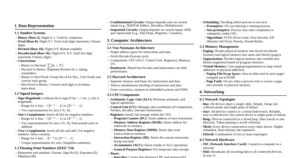
### Earth’s Atmosphere & Essential Variables The Earth's atmosphere is a thin envelope of gases, aerosols, and water vapor held by gravity. It protects life by absorbing UV radiation, warming the surface, and moderating temperature. #### Essential Atmospheric Variables These variables drive meteorological processes and weather patterns: - **Temperature:** Average kinetic energy of air molecules. Gradients drive ocean currents and global winds. - **Atmospheric Pressure:** Weight of the overlying air column. Pressure gradients cause wind. - **Humidity:** Amount of water vapor in the air. Water vapor holds latent heat, which fuels storms upon condensation. - **Wind:** Horizontal movement of air. Transports heat, moisture, and pollutants, balancing Earth's energy budget. ### Blackbody Radiation, Emissivity, & Remote Sensing - **Blackbody:** An idealized object that absorbs all incident electromagnetic radiation and emits a characteristic spectrum based solely on its temperature (Planck's Law). - **Emissivity ($\epsilon$):** Ratio of energy radiated by a real object to a blackbody at the same temperature (value $0$ to $1$). - **Remote Sensing Application:** Weather satellites use infrared (IR) sensors to measure emitted radiation. Knowing surface emissivity allows scientists to calculate accurate temperatures of cloud tops, oceans, and landmasses using the Stefan-Boltzmann Law ($E = \epsilon \sigma T^4$). ### Vertical Structure of the Earth’s Atmosphere The atmosphere is divided into layers based on temperature profiles. Pressure exponentially decreases with altitude across all layers. - **Troposphere ($0$ to ~$12$ km):** - **Temperature:** Decreases with altitude (Earth's surface heats from below). - **Composition:** Contains ~75% of atmospheric mass and 99% of water vapor; almost all weather occurs here. - **Stratosphere (~$12$ to $50$ km):** - **Temperature:** Increases with altitude (inversion) due to UV absorption by the ozone layer. - **Mesosphere (~$50$ to $85$ km):** - **Temperature:** Decreases with altitude, reaching ~$ -90^\circ C$ at the mesopause (coldest point). Most meteors burn up here. - **Thermosphere ($85$ km and above):** - **Temperature:** Increases sharply with altitude (thousands of degrees), but air is extremely thin, so it wouldn't "feel" hot. ### Paleoclimate & Proxy Data - **Paleoclimate:** Study of past climates before instrumental records. - **Proxy Data:** Preserved environmental characteristics used to infer past climate: - **Ice Cores:** Trapped air bubbles reveal past GHG concentrations; isotopic composition indicates past temperatures. - **Tree Rings (Dendroclimatology):** Wide rings = warm/wet; narrow rings = cold/dry. - **Sediment Records:** Pollen, microfossils, and isotopes in lake/ocean beds indicate past flora, fauna, and conditions. - **Understanding Trends:** Proxy data establishes natural climate cycles. Rapid warming since the Industrial Revolution falls outside this variability, attributing current shifts to human activity and aiding future climate models. ### Extreme Weather Events & Global Warming Extreme weather events are significant deviations from usual patterns (e.g., severe storms, droughts, heatwaves). #### Role of Climate Variability & Global Warming - **Tropical Cyclones:** Warmer sea surface temperatures (fuel) lead to stronger storms, faster intensification, and heavier rainfall. - **Heatwaves:** Higher baseline global temperatures increase the frequency and intensity of extreme heat events. - **Droughts:** Higher temperatures increase evaporation. While some areas get more rain, altered atmospheric circulation can lead to prolonged droughts in others. ### Radiosondes & Upper-Air Observations - **Radiosonde:** An expendable instrument package carried by a weather balloon. - **Role:** Provides 3D vertical "soundings" of the atmosphere up to ~$30$ km, crucial for atmospheric models. - **Mechanism:** - Measures **temperature** (thermistors), **pressure** (aneroid sensors), and **humidity** (capacitors) continuously during ascent. - Transmits data via radio to a ground station. - Wind speed and direction are calculated by tracking the radiosonde's position (GPS/radio direction finding). ### Weather Radar Systems - **Weather Radar (Radio Detection and Ranging):** Active remote sensing instrument to locate, track, and estimate precipitation type. - **Working Principle:** 1. Emits microwave pulses. 2. Pulses hit hydrometeors (rain, snow, hail) and scatter back to the radar. 3. **Time delay** = distance to storm. **Strength (reflectivity)** of return = precipitation intensity. - **Applications:** - **Precipitation & Storm Structure:** Multi-elevation scans create 3D maps, identifying severe features (e.g., hail cores). - **Wind Velocity (Doppler Effect):** Measures frequency shift of returning waves to detect movement toward/away from radar, revealing wind shear and rotation (crucial for tornado warnings). ### In-Situ Measurement Techniques In-situ measurements involve direct physical contact with the environment. - **Temperature:** - **Liquid-in-glass thermometer:** Mercury/alcohol expands/contracts. - **Thermistor:** Electrical resistance changes with temperature. - **Humidity:** - **Sling Psychrometer:** Uses dry-bulb and wet-bulb thermometers to determine relative humidity. - **Atmospheric Pressure:** - **Aneroid Barometer:** Flexible metal box (aneroid cell) compresses/expands with pressure changes. - **Wind:** - **Cup Anemometer:** Measures speed (cups rotate faster in stronger winds). - **Wind Vane:** Indicates direction (points into the wind). ### Climate Change: Adaptation & Mitigation Two complementary strategies to address global climate change. #### 1. Mitigation (Addressing Root Cause) Actions to reduce/prevent greenhouse gas (GHG) emissions, slowing global warming. - **Example 1: Renewable Energy Transition:** Replacing fossil fuels with solar, wind, hydroelectric power to cut $\text{CO}_2$ emissions. - **Example 2: Afforestation & Reforestation:** Planting trees to create carbon sinks, removing $\text{CO}_2$ from the atmosphere via photosynthesis. #### 2. Adaptation (Managing Symptoms) Adjusting societies, infrastructure, and ecosystems to unavoidable climate changes. - **Example 1: Upgrading Coastal Defenses:** Building seawalls, elevating roads, restoring mangroves to protect against rising sea levels and storm surges. - **Example 2: Drought-Resistant Crops:** Developing crops resilient to prolonged droughts and shifting precipitation patterns through genetic modification or selective breeding.