GIS Data Models
Shared 5/5/2026•0 views
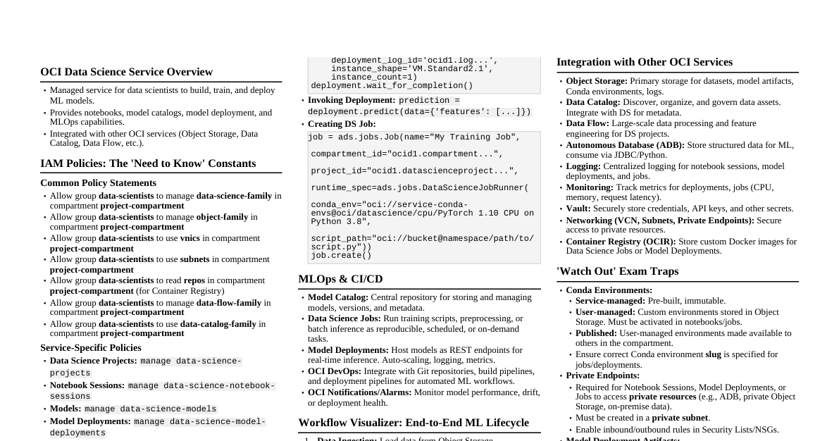
### Introduction to GIS Data Models In Geographic Information Systems (GIS), real-world geographic data is primarily represented using two distinct data models: **Vector** and **Raster**. Understanding the differences between these two is fundamental for any GIS exam. This cheatsheet provides a comprehensive breakdown to help you study. ### Vector Data Model The vector model represents the world using discrete mathematical coordinates (X, Y). It is best suited for mapping features that have clear, defined boundaries. #### Basic Geometries Vector data uses three primary geometric types to represent real-world objects: - **Points:** A single X, Y coordinate. Used for features too small to be represented by lines or areas (e.g., a well, a single tree, a city on a global map). - **Lines (Arcs):** A series of connected points. Used for linear features that have length but no area (e.g., rivers, roads, pipelines). - **Polygons:** A series of connected lines that close to form a shape. Used for features that encompass an area (e.g., lakes, country boundaries, land parcels). #### Key Characteristics - **High Precision:** Because features are defined by exact coordinates, zooming in does not degrade the quality of the image (no pixelation). - **Complex Structure:** The data structure is more complex because it must store topology (how features relate to one another, like which polygons share a boundary). - **Best Uses:** Cadastral mapping (property lines), network analysis (finding the shortest driving route), and representing administrative boundaries. ### Raster Data Model The raster model represents the world as a continuous surface divided into a regular grid of square cells, commonly known as pixels. Every cell in the grid contains a value representing information about that specific location. #### Basic Geometries - **Grid Cells (Pixels):** The entire map is divided into equal-sized squares. If a feature falls inside a cell, that entire cell takes on the value of the feature. #### Key Characteristics - **Cell Resolution:** The size of the cell dictates the detail of the map. A 1-meter resolution means each pixel represents 1x1 meters on the ground. Zooming in past the resolution reveals the individual square pixels (pixelation). - **Simple Structure:** The data is basically a matrix of values, which makes mathematical modeling and map algebra very fast and straightforward. - **Best Uses:** Continuous data that changes gradually across a landscape (e.g., elevation, temperature, rainfall distribution) and remote sensing data (satellite imagery, aerial photographs). ### Vector vs. Raster Comparison Table This table summarizes the core differences for quick revision: | Feature | Vector Data Model | Raster Data Model | | :--- | :--- | :--- | | **Basic Unit** | Points, Lines, Polygons (Coordinates) | Grid Cells / Pixels | | **Best Used For** | **Discrete** features (roads, buildings, borders) | **Continuous** features (elevation, temperature, imagery) | | **Data Structure** | Complex (stores topology and coordinates) | Simple (a matrix of rows and columns) | | **Storage Size** | Generally **smaller** (only stores data where features exist) | Generally **larger** (must store a value for every single cell, even empty ones) | | **Spatial Precision** | Very high (resolution independent) | Limited by the cell size (resolution dependent) | | **Visual Quality** | Smooth, exact lines; looks like a traditional map | Can look "blocky" or pixelated when zoomed in | | **Analysis Strengths** | Network analysis (routing), proximity (buffering) | Surface analysis, map algebra, overlaying multiple layers | | **Common File Types** | Shapefile (.shp), GeoJSON, KML | TIFF, JPEG, DEM, Grid | ### Exam Tip A common GIS mantra is *"Raster is faster, but Vector is corrector."* This highlights that raster grids are processed quickly for complex spatial math, but vector data provides much more accurate and precise boundaries.